|
What
is 'Inner
Space?' You've probably not heard of the term.
But,
everyone has heard about Outer-Space.
Humans
have evolved to live on land, walk, run and climb hills and trees. That
is our natural environment, where we need to breathe air to survive.
We
can swim in water; not very well compared to fish and marine mammals,
and can only stay submerged for a couple of minutes by holding our
breath. But we cannot fly, even though we could breathe.
Both
Outer and Inner spaces, are areas where humans cannot breathe naturally.
So cannot sustain human life. They are alien to us. But the life beneath
the sea sustains life on land reliant on oxygen. Hence, is vital to
human survival.
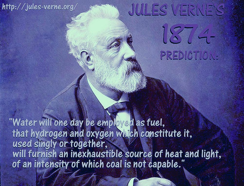
With
our intelligence, we have artificially overcome our natural evolutionary
barriers, to travel faster over water, and fly at supersonic speeds. We
have even escaped our atmosphere into space, and gone to the Moon
and back, as Jules Verne predicted. We have also been underwater in
submarines, just as in '20,000
Leagues Under the Sea' and to the bottom of the ocean in
bathyspheres.
And
now we use remotely operated unmanned vehicles with cameras and sensors,
to explore without breathing apparatus. Enabling us to re-discover
wrecks like the Titanic and Ernest Shackleton's 'Endurace,' recently discovered
on the 5th March 2022, 107 years after sinking in 10,000 feet of water
in the Weddell Sea.
If
the importance of our oceans was taught in schools, as part of an educational
curriculum, they may not have become so polluted and acidified as
they are today. They may also be better understood and documented.
Ocean
awareness, or literacy is not presently high on academic agendas. It
is a shocking statistic that we know more
about Outer Space, than we do our underwater kingdom. Televised
documentary programmes have done a great deal to make life under the waves more
popular, highlighting the marine litter problem that is of major concern
to marine biologists. With plastic now seen in the remotest corners of
the globe and deepest trenches of the ocean.
The
ocean has swallowed umpteen civilizations, just the past 10,000 years.
We may never discover other lost towns and cities, such as to understand
our past, or even explore those we know of, unless the secrets of the
ocean are shared. A sample of Lost Civilizations are below:
LOST
CIVILIZATIONS - AS A TASTER
The
legend of Atlantis was created by Plato some 2,300 years ago. Plato
claimed that this utopian civilization, that allegedly existed 9,000
years before even his time, was punished by the gods for becoming
selfish, greedy, and amoral and thus sunk into the seas. Which sea or
ocean is not known, but it most likely be in the Mediterranean
or Atlantic
- fictionally.
YONAGUNI
JIMA - JAPAN
The Yanaguni Monument is Japan’s Atlantis. Steeped in mystery and
controversy, off the coast of the Ryukyu Islands there lie strangely
even shapes which some scientists believe can only be manmade and point
to an ancient civilization submerged some 10,000 years ago. A
pyramid-shaped structure, an arch, staircases, and other shapes complete
with markings that could be ancient script, have reportedly been
identified, all hinting to a lost civilization. Others say that the
structures are purely naturally-occurring, not unlike the symmetrical
basalt columns found in Iceland or on the Giant’s Causeway in Northern
Ireland.
DWARKA
- INDIA
The city of Dwarka, or “Gateway to Heaven,” was discovered submerged
some 100-feet below the Gulf of Cambay in 1988. Ancient structures,
pillars, grids of a city, and ancient artifacts were found. Steeped in
mystery, some believe them to be at least 10,000 years old, others say
they could be 5,000 years of age, yet others are sure that they date
from the Middle Ages. Yet, others claim that in 1473 the Gujarat Sultan
Mahmud Begada attacked the city and destroyed the temple of Dwarka.
Either way, this is a true underwater city, long lost, full of mystery
and legend, and magnificent.
ATLIT-YAM
- ISRAEL
So many underwater complexes allege to be the oldest, but this one seems
to have a definite claim to the title. Off the coast of Israel in the
Mediterranean Sea, lies this Neolithic settlement, thought to be around
8,000 years old. Discovered in 1984, in 30-feet deep water, there are
buildings, graves, even the odd skeleton. But the most amazing find must
be the seven megaliths arranged in a circle, like an underwater
Stonehenge. It is believed that an earthquake and subsequent tsunami
resulted in the settlement becoming submerged.
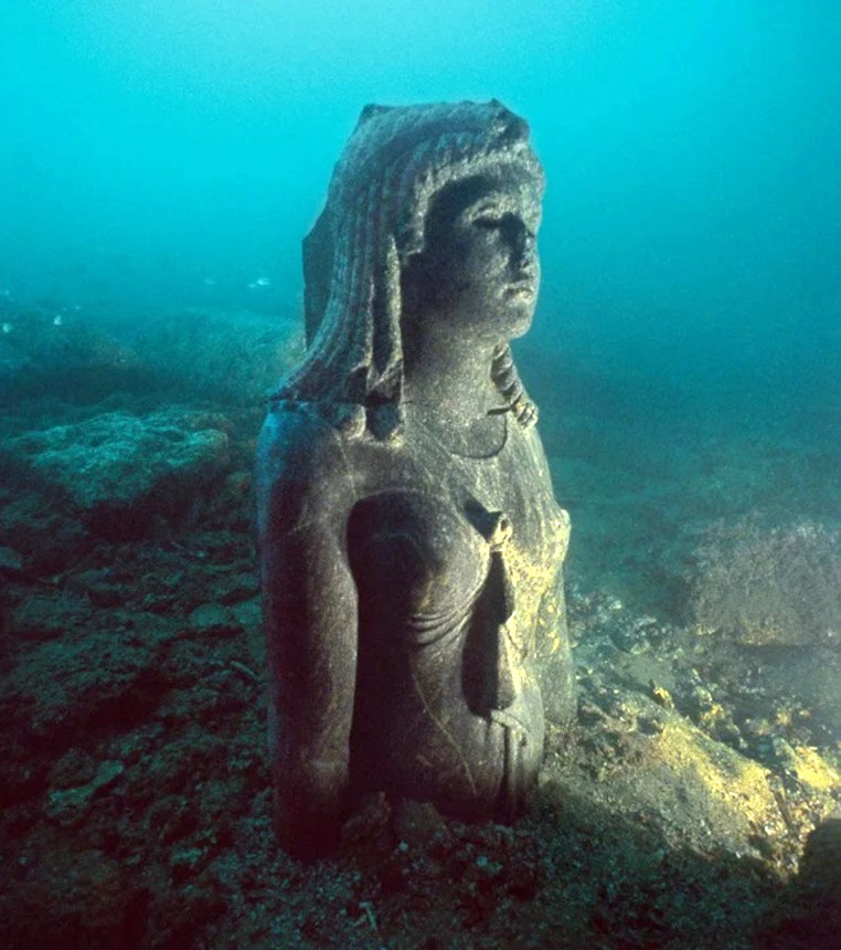
CLEOPATRA
- This magnificent statue of the Ancient Egyptian
Pharaoh queen is underwater at
Thonis, Alexandria.
In fiction, an ocean
adventurer thwarts a plot by occultists to digitally reincarnate
Cleopatra from her mummy. Cloning
and other medical advances, make this theoretically a possibility. Just
like Jurassic
World. But, you'd need to find the Queen's sarcophagus and hope her DNA
was complete enough to even stand a chance of making that happen in the
real world.
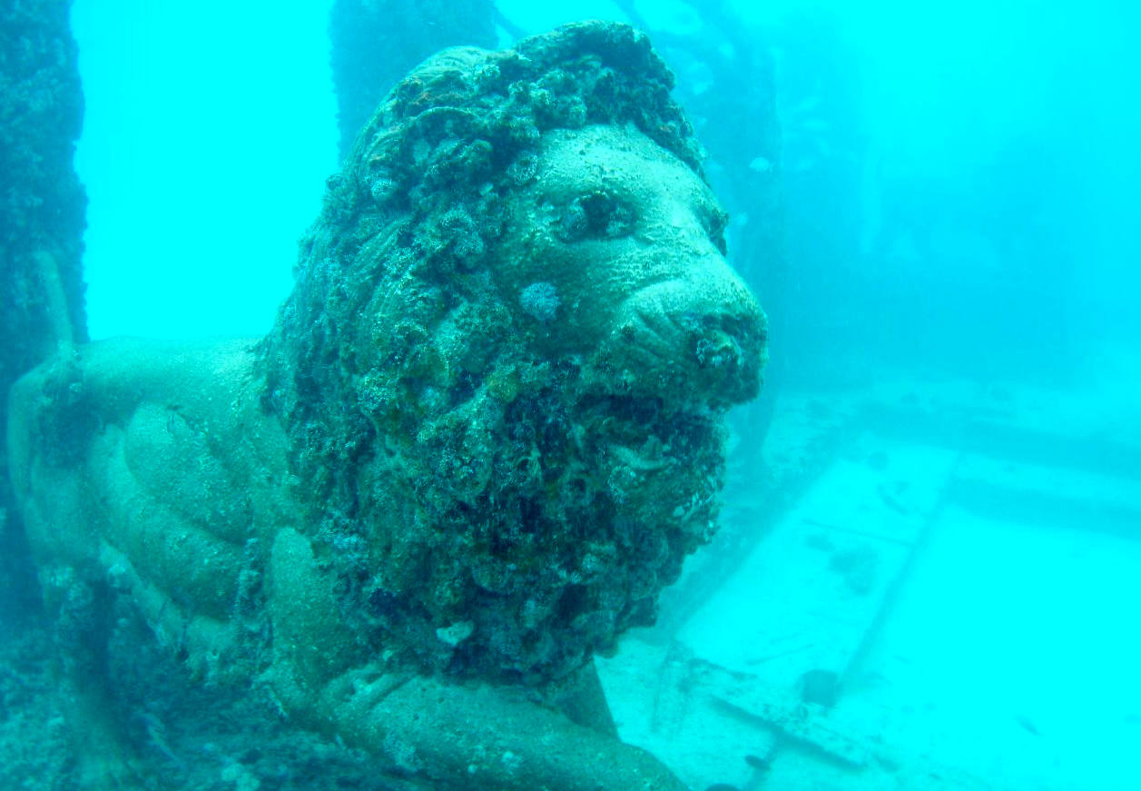
THONIS-HERACLEION
AND ALEXANDRIA - EGYPT
Long lost Alexandria has just as many legends and mysteries spun around
it as Atlantis, but this one is real. And it has been found. And there
are two sunken cities for the price of one. Alexandria’s remains lie
literally a few feet off the coast, while Thonis-Heracleion rests a
little farther off the coast of today’s Alexandria. Both spectacularly
well-preserved, considering the ruins are more than 2,000 years old and
littered with various shipwrecks, dropped anchors, even lost - and found
- gold treasures. Temples and buildings of Thonis-Heracleion were once
separated by canals, not unlike Venice, but how and why exactly the city
became submerged is still a mystery, save for the earthquake in 365AD
and subsequent tsunami. Then again, Venice is sinking.
While Thonis-Heracleion is only accessible for scuba
divers, Alexandria’s ruins may one day be on view via the proposed
Underwater Archeological Museum of Alexandria.
BAIA
- ITALY
Another once wicked city submerged underwater. This time it was not
pirates that were wicked, but hedonistic Romans that flocked to Baia,
dubbed the Las Vegas of ancient Rome, some 18 miles outside of Naples on
the Mediterranean coast. Alas, as seems to happen with wicked cities, it
sank. Most likely due to the region’s rather active volcanic
activities. The 2,000-year-old remains are in superb condition with many
intact statues found, together with houses and temples. Most of the city
lies at a depth of fewer than 20 feet, and some of it even visible above
water. The archaeological park can be explored by donning a snorkel.
PHANAGORIA
- RUSSIA
Once reportedly the largest city of ancient Greece and the capital of
the Bosphoran Kingdom, Phanagoria was founded around 540 B.C. and
stretched across the Taman Peninsula in the Black
Sea, now part of Russia. A third of the old city is submerged in the
waters of the Black Sea, but two-thirds are on land, making for an
enormous archaeological site, dry and wet, with new discoveries still
being made.
PAVLOPETRI
- GREECE
In 1967 an oceanographer discovered what looked like ancient ruins and a
year later a survey produced a plan of a prehistoric town thought to be
Mycenaean, lying in three to 12 feet of water in the Peloponnese, in
south-western Greece. Pavlopteri, named after a nearby settlement, has
since been touted as the oldest underwater city, dating to the Bronze
Age, and occupied from the third millennium until 1100 B.C. Located
steps away from a sandy beach, it is a miracle that it is the good
condition it is.
PORT
ROYAL - JAMAICA
On June 7, 1692, a massive earthquake followed by a tsunami killed 2,000
people and submerged the city of Port Royal in Jamaica. Once called the
“wickedest city on earth,” Port Royal was home to real-life pirates
of the Caribbean,
and the city’s sinking was deemed an act of God. But that did not stop
the pirates, who just moved farther up the coast. Today it is deemed to
be one of the best-preserved underwater cites in the world, with only a
few items having been removed and placed into various museums across
Jamaica. You can scuba dive to the sunken city but need special
permission from the authorities.
Then
there are flooded towns, and shipwrecks bearing lost treasures - the
mystery continues.
There
are many islands currently under threat of flooding today:
ATLANTIS
- MEDITERRANEAN SEA
ATLIT-YAM - ISRAEL
BAIA - ITALY
DWARKA - INDIA
PAVLOPETRI - GREECE
PHANAGORIA - BLACK SEA
PORT ROYAL - JAMAICA
RUNGHOLT
- DENMARK
THONIS-HERACLEION AND ALEXANDRIA - EGYPT
YONAGUNI JIMA - JAPAN
SHICHENG, CHINA
- This city was considered to be 1,300 years old and known as the lion city. In 1959 the city was flooded because the government was constructing a dam on the famous Xin’an River.
Thus, does not qualify as a natural flooding. The man made flood ended
with the Qiandao Lake. Shicheng was constructed in 25-200 AD during the Eastern Hand Dynasty. It’s ancient buildings and other structures are thus
adorned with rich Chinese craftsmanship. The city includes 265 memorial arches, 5 gates, paved
streets and several stone structures that belong to the Ming and Qing dynasties. Because the diving routes aren’t fully mapped, only trained divers are permitted to visit.
ISLAND
NATIONS UNDER THREAT OF FLOODING
Cabo
Verde, Republic of
The islands of Cabo Verde in the Atlantic Ocean, also
known as Cape Verde, are the result of volcanic activity that happened
between eight and 20 million years ago. Located about 373 miles from
western Africa, the ten Cabo Verde islands are inhabited by people of
African and Portuguese descent, many of whom live along the water.
There are nearly 600 miles of coastline in this archipelago. Flash
floods, tropical cyclones, and torrential rains threaten Cabo Verde. Due
to this country's vulnerability to disasters, population density around
the coastlines, and limited emergency preparedness, this nation is in
danger as seas rise and the planet warms.
Carteret
Islands
The Carteret Islands of Papua New Guinea, located in the South Pacific,
are also called the Kilinailau Islands. This atoll is made up of five
low-lying islands scattered in a 19 mile-long horseshoe shape. The
highest elevation is close to five feet above sea level and these
islands are pummeled by the ocean's waves. Researchers estimate that the
landmass of the Carteret Islands is less than 40% of what it used to be;
the people of Carteret are often called climate refugees because they
have been made to leave their homes for higher ground, many fleeing the
islands entirely. Some have resettled on nearby Bougainville Island.
Fiji,
Republic of
A roughly 11,392-square-mile island nation in the South Pacific, Fiji
also faces many challenges. While its larger islands feature towering
mountains, the low regions of Fiji's 330 islands experience a brutal wet
season that brings tropical storms and flooding. The coasts are at the
greatest risk and are also the most densely populated. When Cyclone
Winston made landfall in 2016, it forced an estimated 76,000 to evacuate
to higher ground. Climate change is expected to dramatically increase
wet and dry extremes in the coming years, and this could prove
devastating for the coasts of Fjij.
Ireland
This is an island with a coastline length of 1,738 miles with the
highest elevation being 3,415 ft above the sea levels. Each and every
year, the rate at which the sea levels are rising is increasing. The two
main reasons given to this trend emanate from global warming. One is
expansion of water due to sea
warming and the other is massive melting of land ice. Some of the
adverse effects of the rising sea levels to the country include;
flooding, poor water quality, and adverse effects on fishes which are
sensitive to changes in temperature.
Hawaii
About 65,000 people in Hawaii live
within the 100-year coastal floodplain; by 2050, the the state faces the
greatest percentage increase in coastal flooding threat of any state.
Even though the state has recognized the risk climate
change poses for coastal flooding, it has not yet put
adaptation plans in place. By 2050, an additional 152,000 people are
projected to be at risk due to sea level rise.
Japan
Japan is an island country in East Asia consisting of over 6,852 islands
in the Pacific Ocean. The country is facing rising sea levels caused by global
warming. It is estimated that a two degrees Celsius increase in the
global temperature will submerge an area occupied by over 18 million
people while if the increase reaches 4 degrees Celsius, more than 34
million people will be left homeless in the country. The country’s
largest city which is also the capital, Tokyo, is also likely to become
swampy if the rate of the rising sea levels is not checked.
Kiribati
Kiribati is an Island country in the Pacific Ocean consisting of 33
atolls and one solitary island. There are four groups of islands, namely
the Banaba, Gilbert Islands, Phoenix Islands, and the Line Islands. In
1999, two islands which were not inhabited were submerged in water after
the heavy El Nino downpour. The United Nations has predicted a sea level
rise of about 20 inches by the year 2100. This will make the bulk of
arable land in Kiribati far too saline. A huge chunk will also be
submerged. Although the risk of the entire country being submerged is
low, there is a huge risk of cyclones stripping the low-lying island of
their vegetation and structures.
Maldives
The Maldives is
an island archipelago in the Indian
Ocean atop of a vast submarine mountain range. It
has an average ground level of 4 ft above the sea level, making it the
world’s lowest country. The highest point in the island is only 7 feet
above the sea level. There are about 1100 corals islands which are
groups in a double chain of 26 atolls which are spread over 35,000
square miles. This makes it the most dispersed country in the world.
Maldives is ranked as one of the most endangered countries in the world
due to rising sea levels and flooding brought about by climate change.
According to the Maldivian president, if carbon emissions continue at
the prevailing rate, the country will be under water by the year 2020.
There are plans by the Maldivian government to purchase land in India,
Sri Lanka, and Australia to
relocate the population which will be affected by the rising sea levels.
Marshall
Islands, Republic of the
1,225 islands spread over 29 coral atolls make up the Republic of the
Marshall Islands in the Pacific Ocean. Most of them are less than seven
feet above sea level and few are more than a mile wide. If the sea
levels rise just 3.3 feet more, many of the Marshall Islands will be
lost. For example, Roi-Namur of the Kwajalein Atoll will probably be
almost completely flooded by no later than 2070. The Marshall Islands
are working to combat rising seas by revamping their infrastructure and
creating safeguards against flooding, but this nation, like the others
on this list, is facing an uphill battle.

Micronesia, Federated
States of
The Federated States of Micronesia (FSM) in the Pacific Ocean consists
of 607 islands containing both mountains and low-lying coral atolls.
These islands are grouped into the states Kosrae, Chuuk, Yap, and
Pohnpei. The FSM is not to be confused with Micronesia, a region west of
Polynesia and north of Melanesia that includes Kiribati and Palau. The
FSM has an area of roughly 271 square miles, but its islands are spread
across 1,700 miles—and many are sinking. A 2017 study by the Journal
of Coastal Conservation found evidence of severe coastal erosion
throughout the FSM that can be traced to rising
sea levels.
Palau
Palau is an archipelago of over 700 islands located in the Pacific
Ocean. Traditionally, the people of Palau have learnt to live with the
sea and depended on it economically and socially. However, in the recent
past, the sea has covered parts of these tiny islands which has caused
panic to the inhabitants. Increasing temperature of sea water also leads
to massive coral bleaching and thus the country lost about 30% of its
corals. The rising sea levels have also affected vegetation and agriculture in
the area as sea water now occupies more land mass.
Sarichef
Island
Sarichef Island is a small stretch of land off the coast of northwestern
Alaska, a U.S. state that is growing warmer at a rate two times faster
than the rest of the world.20
Consisting of the village Shishmaref and an airport, there is little
space to move around, but many have no choice. In 2016, the Inuit
villagers of Shishmaref voted to relocate their ancestral home. Every
year, more Sarichef residents are forced to do the same as global
warming and glacial melting accelerate sea-level rise. Between 1985 and
2015, as much as 3,000 feet of Sarichef land eroded away.
Seychelles
Seychelles is made up of 155 islands in the Indian Ocean on the east
coast of Africa. The majority of the highlands are not inhabited. 98% of
the total population inhabit only 54 of the islands. The pace of rising
sea levels in Seychelles has been unprecedented in the past hundred
years. The sea has risen by seven inches which is about 10 times the
average in the past 10 years alone. These developments have massive
impacts on the economy of the country since about 85% of economic
activities occur along the coastline. With the increased erosion along
the beaches, tourism is likely to be negatively affected.
An archipelago comprised of 115 islands in the Indian
Ocean, Seychelles
is a biodiverse and naturally beautiful East African country. Roughly
half of this nation is made up of nature reserves and parks and
Seychelles is home to the Aldabra Atoll, one of the largest coral atolls
in the world. Unfortunately, climate change and ocean acidification have
worn away coral reefs and put Seychelles' densely populated and
developed coastlines at risk. Between roughly 1914 and 2014, the sea
level of Seychelles rose about 7.9 inches. If the sea level were to rise
3.3 feet more, about three-quarters of Seychelles would be submerged.
Solomon
Islands
The Solomon
Islands is made up of six major islands and more
than a thousand smaller islands. The islands are low-lying which makes
them vulnerable to the ever-rising sea levels. At least five of these
islands have been reported to have been lost completely due to the
rising sea levels. Another island, Nuatambu Island, has lost more than
50% of its area to the sea leaving more than 15 families homeless. Many
families have been forced to relocate to higher grounds inland or even
to other islands in severe cases.
Tangier
Island
Located in the Chesapeake Bay, Tangier Island is a small atoll off the
coast of mainland Virginia. This island has lost 65% of its landmass
since 1850, and some of the roughly 700 residents are being displaced as
their homes flood with seawater. Many islands in the Chesapeake Bay have
already started disappearing as sea levels in the Chesapeake Bay rise at
an average rate of 0.16 inches annually. Coastal regions of the Bay and
tiny islands like Tangier don't have long before they are likely to be
underwater; scientists believe Tangier may drown by 2050.
Torres
Strait Islands
The Torres Strait Islands are 274 islands in the strait between
Australia's Cape York Peninsula and New Guinea. 17 of these islands are
inhabited by about 4,500 islanders in total. Every year, the sea level
rises up to 0.3 inches in the Torres Strait and the ocean grows warmer.
Many marine species living around the Torres Strait Islands are being
negatively affected by ocean acidification and increased temperatures,
and the clean water reservoirs on the islands are likely to be inundated
with seawater as the planet warms and wet seasons grow more intense.
Coastal erosion is a pressing issue as well.
Tuvalu
Tuvalu is an island country comprising of nine islands (atolls) in the
Pacific Ocean. The rising sea levels are of a great concern as the
islands are low lying at an average of 6.6 ft above the sea level. The
highest point of the country is a mere 15ft above the sea level. The
University of Hawaii tracked sea levels in the nation for 23 years, a
project that began in 1978.Their study showed a rise of 1.2 mm annually.
Gradual sea rise has no real threat to coral highlands since they are
also growing. However, if the sea rises faster than the growth of the
reefs, a real threat to the islands is posed. Tropical cyclones also
pose a great danger to the citizens of Tuvalu. That was the impassioned
plea from Tuvalu’s Prime Minister, Kausea Natano to world leaders
attending the COP26 in
Glasgow.
|