|
The Yanaguni Monument is Japan’s
Atlantis. Steeped in mystery and controversy, off the coast of the Ryukyu Islands
(border East
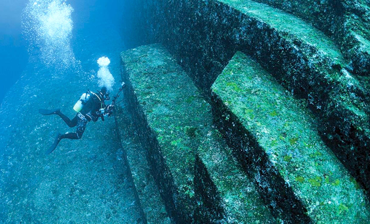
China & Philippine Sea) there lie strangely even shapes which some scientists believe can only be manmade and point to an ancient civilization submerged some 10,000 years ago. A pyramid-shaped structure, an arch, staircases, and other shapes complete with markings that could be ancient script, have reportedly been identified, all hinting to a lost civilization.
Others say that the structures are purely naturally-occurring, not unlike the symmetrical basalt columns found in Iceland or on the Giant’s Causeway in Northern Ireland.
To see this interesting complex, you'll need a wet suit and scuba gear
to dive into Inner
Space.
The Yonaguni Monument (Japanese
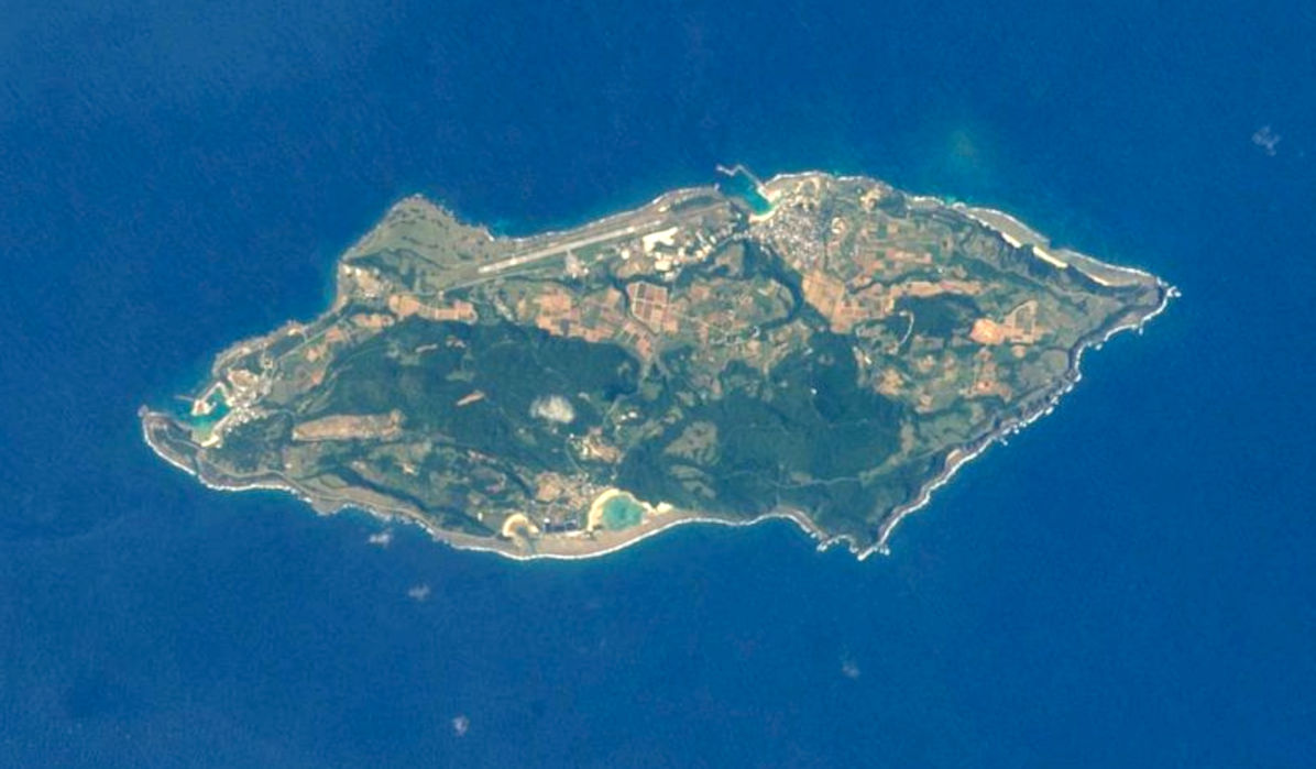
与那国島海底地形, Hepburn: Yonaguni-jima Kaitei Chikei, lit. "Yonaguni Island Submarine Topography"), also known as "Yonaguni (Island) Submarine Ruins" (与那国(島)海底遺跡, Yonaguni(-jima) Kaitei Iseki), is a submerged rock formation off the coast of Yonaguni, the southernmost of the Ryukyu Islands, in Japan. It lies approximately a hundred kilometres east of Taiwan.
Marine geologist Masaaki Kimura claims that the formations are man-made stepped monoliths. These claims have been described as pseudoarchaeological. Neither the Japanese Agency for Cultural Affairs nor the government of Okinawa Prefecture recognise the features as important cultural artifacts and neither government agency has carried out research or preservation work on the site.
DISCOVERY
The sea off Yonaguni is a popular diving location during the winter months because of its large population of hammerhead sharks. In 1986, while looking for a good place to observe the
sharks, Kihachiro Aratake, a director of the Yonaguni-Cho Tourism Association, noticed some singular seabed formations resembling architectural structures. Shortly thereafter, a group of scientists directed by Masaaki Kimura of the University of the Ryūkyūs visited the formations.
The formation has since become a relatively popular attraction for divers despite strong currents. In 1997, Japanese industrialist Yasuo Watanabe sponsored an informal expedition including pseudoarchaeology writers John Anthony West and Graham Hancock, geologist and fringe theorist Robert Schoch, photographer Santha Faiia, a few sport divers and instructors and a film crew for Channel 4 and Discovery Channel. Another notable visitor was freediver Jacques Mayol, who wrote a book on his dives at Yonaguni.
MAN MADE
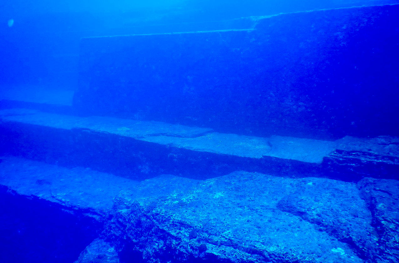
Kimura first estimated that the monument must be at least 10,000 years old, dating it to a period when it would have been above water, and therefore surmised that the site may be a remnant of the mythical lost continent of Mu. In a report given to the 21st Pacific Science Congress in 2007, he revised this estimate and dated it to 2,000 to 3,000 years ago because the sea level then was close to current levels. He suggested that after construction, tectonic activity caused it to be submerged below sea level. Archaeologist Richard J. Pearson believes this to be unlikely. Kimura believes he can identify a pyramid, castles, roads, monuments and a stadium. He further stated that he believes the structures to be remnants of Yamatai culture.
Supporters of artificial origin, such as Graham Hancock, also argue that while many of the features seen at Yonaguni are also seen in natural sandstone formations throughout the world, the concentration of so many peculiar formations in such a small area is highly unlikely. They also point to the relative absence of loose blocks on the flat areas of the formation, which would be expected if they were formed solely by natural erosion and fracturing. Robert M. Schoch, who believes the monument was formed geologically, has noted that the rocks are swept with strong currents.
NATURAL FORMATION
Geologist Robert Schoch believes that it is most likely natural. Schoch observed the sandstones that make up the Yonaguni formation to "contain numerous well-defined, parallel bedding planes along which the layers easily separate. The rocks of this group are also criss-crossed by numerous sets of parallel, vertically oriented joints in the rock. These joints are natural, parallel fractures by which the rectangular formations seen in the area likely formed. Yonaguni lies in an earthquake-prone region; such earthquakes tend to fracture the rocks in a regular manner." He also observes that there are similar formations on the northeast coast of Yonaguni. John Anthony West visited the monument with Schoch and agreed that it was a natural formation and that Kimura "had not looked carefully enough at the natural processes at work." Schoch also believes that the "drawings" identified by Kimura are natural scratches on the rocks, and suggests that the "walls" are simply natural horizontal platforms which fell into a vertical position when rock below them eroded, and the alleged roads are simply channels in the rock.
German geologist Wolf Wichmann, who studied the formations in 1999 during an expedition organized by Spiegel TV, and in 2001 by invitation of Graham Hancock, concludes that it could be formed by natural process.
At Sanninudai, there are onshore step-like sandstone formations similar to those of the Yonaguni. Robert Schoch, as well as Patrick D. Nunn, Professor of Oceanic Geoscience at the University of the South Pacific, note that the formations are purely natural.
RYUKYU
ISLANDS
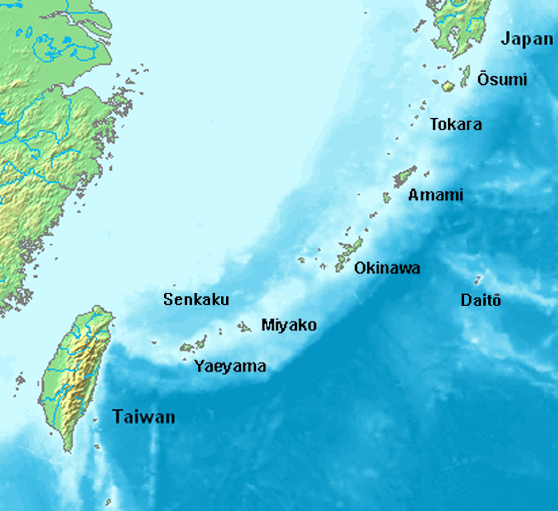
The Ryukyu Islands, also known as the Nansei Islands (南西諸島, Nansei-shotō literally "Southwest Islands") or the Ryukyu Arc (琉球弧, Ryūkyū-ko), are a chain of Japanese islands that stretch southwest from Kyushu to Taiwan: the Ōsumi, Tokara, Amami, Okinawa, and Sakishima Islands (further divided into the Miyako and Yaeyama Islands), with Yonaguni the westernmost. The larger are mostly high islands and the smaller mostly coral. The largest is Okinawa Island.
The Ryukyu Kingdom was a kingdom in the Ryukyu Islands from 1429 to 1879. It was ruled as a tributary state of imperial China by the Ryukyuan monarchy, who unified Okinawa Island to end the Sanzan period, and extended the kingdom to the Amami Islands and Sakishima Islands. The Ryukyu Kingdom played a central role in the maritime trade networks of medieval East Asia and Southeast Asia despite its small size. The Ryukyu Kingdom became a vassal state of the Satsuma Domain of Japan after the invasion of Ryukyu in 1609 but retained de jure independence until it was transformed into the Ryukyu Domain by the Empire of Japan in 1872. The Ryukyu Kingdom was formally annexed and dissolved by Japan in 1879 to form Okinawa Prefecture, and the Ryukyuan monarchy was integrated into the new Japanese nobility.
Ocean
literacy
could be taught in schools, as part of an educational
curriculum to raise awareness of just how important the subsea
kingdom is for land dwellers.
What
lost treasures might we discover as the mysteries of the deep unfold,
armed with new underwater technology and an army of freshly educated
researchers with an interest in the deep.
ATLANTIS
- MEDITERRANEAN SEA
ATLIT-YAM - ISRAEL
BAIA - ITALY
DWARKA - INDIA
PAVLOPETRI - GREECE
PHANAGORIA - BLACK SEA
PORT ROYAL - JAMAICA
RUNGHOLT
- DENMARK
THONIS-HERACLEION AND ALEXANDRIA - EGYPT
YONAGUNI JIMA - JAPAN
REFERENCE
https://www
|